This research is part of my bachelor thesis which investigates the access to open geographical information for visual impaired people. By means of a prototype, possibilities like target profiles, personalised parameters and textual representation of geodata are shown. The implementation is done using a vector map and data from OpenStreetMap.
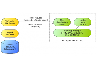
Instead of using pre (server) rendered raster images, the browser itself takes care of rendering vector data which represents the features in the tile. For example roads are sent as LineStrings, buildings, land and water as Polygons and POIs as Points. Javascript based on vector-osm converts them to SVG, the browser takes care of the rendering. Vector tiles are coming from Mapnik Vector Tiles in GeoJSON format using OpenStreetMap as data provider.